With a blip from New Mexico. Enjoy!

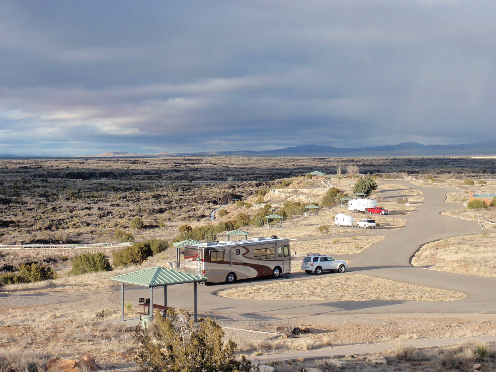
Valley of Fires State Park, New Mexico. You can walk on this lava field, either on the mile or so trail that's visible here, or anywhere you like by taking a trailhead from the campground. This dried lava is either ropey (easy to walk on) or extremely sharp (easy to cut a hand or knee on). Lots of cracks to go around or up-and-over by scrambling. And windy. Extremely windy with ice-cold temps (this was March). Made for a very chilly run on the trail in the mornings. In the foreground is my rig, with Patchouli's outdoor-access crate attached; he goes in and out at will into the basement area, and uses a kitty door from the basement into the rest of the rig via a laundry chute.

Our two rigs at Valley of Fires, NM--Ken's motorhome in the foreground, my fifth wheel and red truck beyond. This was the closest we could get our rigs at this campground because of site length, site slope, and access to clean electric (the first site Ken tried kept blowing his fuses because of a bad ground).

View from Dead Horse Point State Park, Utah. This is a famous gooseneck bend in the Colorado River, photographed by nearly everyone who's ever been here. You could probably compile an interesting time-lapse video of the place if we gathered everyone's shots from over the years.
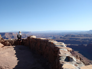
Viewpoint at Dead Horse Point. This place is so-named from a former use--it's a long narrow peninsula of mesa that's barely 50 feet wide at its neck before it opens into an acres-large lobe at the edge of the canyon here. Cowboys used to herd wild horses onto the promontory and seal off the neck with a fence; horses were then culled for the best. Legend has it that one year the unwanted horses were inexplicably left corralled on the point, and they all died for lack of food and water. Now the place has a small campground and lovely photo ops from nearly every angle.

Looking east from Dead Horse Point. Those blue bits of water are salt evaporation pits, and the range is called the La Sal Mountains--which means salt, but there isn't any on the mountains, it just looked like it to the early European explorers.

A day hike at Fisher Towers, less than an hour east of Moab, Utah. Ken's looking up at the wiggly-shaped blade of rock, where he's just spotted a climber sitting at the very top!

A closer look at that rock-climber's chosen perch, several hundred feet up. There were two climbers--we saw them on their way down an or so hour later, and then met them in the parking lot. Fisher Towers is apparently a climber's paradise.

Desert view, looking west-ish, from the end of the Fisher Towers trail.

These rocks from the Fisher Trail hike made me think of a couple of fat dwarves viewed from the back.

We didn't see many desert flowers in April, despite all the rains we've been having. Perhaps we're not in the right place (in Moab) for a lot of bloom.

After two weeks in Moab, the weather turned good enough to venture on a longer hike in the Needles District of the Canyonlands National Park. This is a good two hours from Moab, with great camping for smaller rigs and tents. The campsite takes no reservations and was completely full; only a few sites would have fit us. Meanwhile, we took the Confluence hike, an 11-mile, somewhat strenuous round trip that gets you to a cliff that overlooks the point where the Green River and the Colorado River join.

One of the many cairns on the Confluence trail. This track was easy to follow, overall.

The infamous confluence. The Green River is at the left, the muddier, ruddier Colorado at the right. From here, the river flows south as the Colorado. The Green River starts way up in Wyoming.

A lucky photo of a raven as it flew by us, riding the drafts from the cliffs at the confluence.

View of the "needles" of the Needles District, as seen from the Confluence trail. We didn't have time to hike this region on this trip; I look forward to coming back to do that, because you can walk among all the columns of rocks.

One of the many lizards we saw sunning on the cairns. Their coloring is perfect for their environment. Usually they scuttled away when we approached, but this one kindly hung around long enough for a photoshoot.

This is the beginning of the Poison Spider jeep trail in Moab. Jeeps were everywhere in town and on the hills the whole three weeks we were in Moab--and that was even after the annual week-long JeepFest that had booked the town right before we arrived. The dark band across the middle of this photo is where the rock cliff drops off into the Colorado River below.

Another desert flower sighting; astoundingly delicate petals given its environment. The white fades to pink as the bloom dies.

One of the many gorgeous views from the Poison Spider jeep trail.

Along the Poison Spider jeep trail. Well, we're actually not on the trail here--we veered off the off-road bit to cross an unmarked expanse of slick rock and washes. It was fun just choosing a direction and heading out over the terrain. Our plan was to shortcut the many switchbacks from the actual jeep trail, which cut off about a mile of walking. The sandstone is very easy to walk on, with as much friction as sandpaper. Even climbing somewhat steep rocksides is doable, although we were often forced to go way roundabout, or up a very narrow crevice, to negotiate some of the higher and longer formations.

Signs of critters in a wash.

Meeting up with the road again. We knew we were close by all the engine noise.

Note the dark streaks on the rock--tire rubber from thousands of jeeps, plus lots of little oil drops everywhere.

This is a mild example of the rockier parts of these trails. The leading edges often have grooves ground into them where many a jeep has hit bottom climbing over. Struts, shocks, and frames take a beating, even though these guys crawl at 1mph, and most jeeps are tricked out with rollbars, humongous tires, and all the rest. The trails are usually wide enough for only one vehicle at a time. The guy on the left is waiting to come down--we could see a long line of jeeps coming that the driver couldn't, so we hung around long enough to give him the OK to move on down. On another, steeper jeep trail hike we took a few days earlier, we came upon a crippled jeep all jacked up, with its axle and differential gutted. We met the owners on the way back--three guys all monkeying around to get the thing running again. It had already been there a day.

Goblin Valley State Park, UT. For those of you who have seen
Galaxy Quest, this is the place where they filmed the retrieval of the beryllium sphere. I kept expecting little blue gremlins to pop up, or a rock monster to come crashing through.
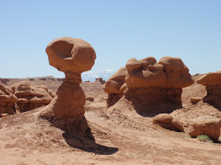
Really weird formations here. You get to walk among them, which is fun.

Keebler Elf homes?

In a slot canyon at Little Wild Horse Canyon, a short distance from the entrance to Goblin Valley State Park. This easy 4-mile hike was really interesting, walking and clambering through crevices and along washes with beautiful stone walls towering hundreds of feet on both sides. In summer, flash floods are a very real danger, and we saw lots of tree debris from previous floods.

Huntington State Park, Utah. Those waves are water crashing on the shore of a reservoir! The winds here were so strong we stayed only one night--just too uncomfortable to be outdoors, and there were no hookups anyway, and another storm on its way. So we headed north toward Salt Lake City for a full-hookup site at Utah Lake State Park near Provo. Almost no one was there this time of year, and it proved to be a good spot for hunkering down through five days of more rain and cold.

Ken's rig travels toward Provo through rain and snow.
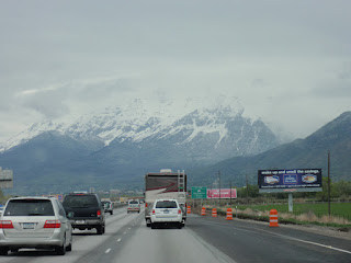
The snow-capped Wasatch Mountains greet us in the Provo/Salt Lake City area. Ah, spring!
 The Gros Ventre river, which runs behind the campground. A prime hangout for moose.
 And here comes one, now--a special treat, since I'm the only one out this far to keep her company. You're supposed to keep a good distance from wildlife, so I stayed down on the river-rock ravine while she moseyed (mooseyed?) along the upper embankment. She knew I was there, but seemed unperturbed enough (and no baby around) that I just quietly backed off a little and let her decide the safe distance. I eventually sat down at the end of the rock swath (a dry creek bed that nearly flooded its banks a week later) and stayed very still, waiting for what would happen next.
 She was the same old girl we saw at the unoccupied part of the campground a couple of days ago. Ms. Moose ambled and munched her way down to the river, drank a sip, took a pee in another spot, sloshed through the river in a large arc around me,...

 ...and stopped at the other side of the bank to keep browsing across the little stream. We were about 30 feet apart and both just hanging out in the morning sun.
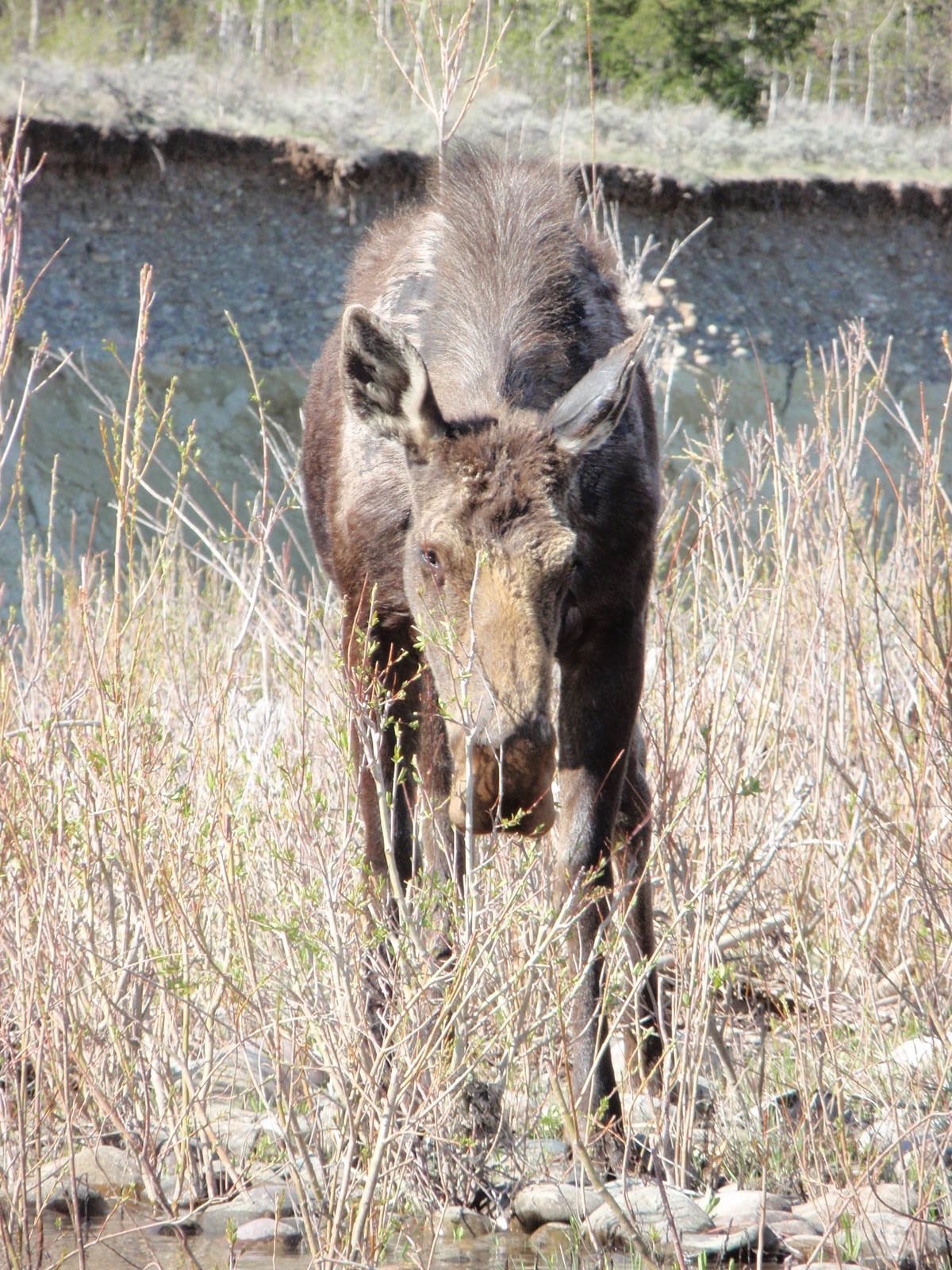
 Looking at her devolving winter coat, I could understand why a popular restaurant in Jackson is called The Mangy Moose.
 After another twenty minutes in each other's company, Ms. Moose wandered away, and I went back to camp feeling very honored and peaceful for the personal encounter.
 As Ken had predicted, other moose greeted us on the occasional morning right by our campsite. That's Ken's car in the foreground. He often spotted them in the far woods while he rode his lifecycle outside the rig.
 Watch your step...moose poop is everywhere.
 A moose and baby we saw from the road en route to Gros Ventre Slide, a huge mudslide that happened years ago and that has left a bowl of a scar in the side of a mountain.
 A rarer sighting--a young bull moose. He's at the back end of our campsite loop, on the path I usually took to the Gros Ventre river.

 Note the other photographer moving in for a better shot. This moose had five people converging from both sides. I decided to stay farther back than the others to give him escape room if he wanted it, but Mr. Moose instead plopped down for a cud chew.
 I sure could have gone for a foot-long telephoto lens at this moment...