Sunday, June 19, 2016

Banff, Canada: Beauty and the Bears

We finally made it into the land of our northern neighbor, for a wonderful two-week stay in Banff National Park, Alberta. Getting there through British Columbia from the west was a glorious 6-hour drive from Vernon BC through orchards, vineyards, and agriculture that lined miles and miles of rivers and lakes that themselves wound through valley after valley flanked by rugged granite mountains. At last the agriculture gives way to forests and stupendous mountain views in every direction. Here are the Canadian Rockies, still melting their snows in June, grand sentinels of time and change. 

We landed in Banff at the beginning of a record heat wave, with temps in the mid 80s drawing out every local to enjoy the sunshine amid busloads of early-season tourists. We avoided most crowds by touring earlier in the day, and packed most of our touring into the first three days to take advantage of the weather. The second week of our stay brought lower than average temps, with mid 40s and some very wet rain for several days, which also gave the nearby mountains a fresh coat of snow. One morning we even had the lightest of snow flurries at campground level...dandruff from the gods filtering through sunshine.

This region must be experienced first hand to be fully appreciated, but here are a few highlights of the trip. 


But first we had to get out of Vernon, BC, in the morning--a plan that was thwarted by the failure of a slideout motor when we buttoned up the rig for travel. No motor, no closing of the slideout. No closing of the slideout, no driving down the road. This was our first showstopper problem since buying the rig new five years ago. Potentially, it could also be a multi-day delay waiting for a new motor/gearbox unit, but handyman "McGiver" Ken crawled under the rig and yanked it out hoping to figure out its problem.


The culprit: a sheared-off "gear key" that is supposed to lock a gear onto the motor's main shaft, so the gear doesn't spin loose around the shaft while the shaft is rotating. Most people would have given up and ordered a new gear key. Ken, of course, managed to manufacture one out of a bit of heavy-duty angle bracket carved off with a dremel tool. With the makeshift repair in place and the whole gearbox reassembled and reinstalled, our slideout comes in like a champ. Total delay: 5 hours. And because we're so high up in latitude here, we have another 7 hours of daylight left for travel, allowing for an ungodly arrival time of near 9 p.m.


On the way to Banff from Vernon, still in British Columbia...an inkling of what the Canadian Rockies have to offer.


A spate of rain near Alberta had us driving through rainbows for fifteen minutes.


Our RV spot for most of our stay in Banff.


The town of Banff is a 15-minute walk from the campground. This shows the main street in 1896, shortly before tourism came booming in with the railway. The fellow is standing with a donkey. The backdrop is Cascade Mountain. Double-click the image for a closer view (of this or any other pic).


Banff's main street today. Same mountain, but lots more restaurants, galleries, clothing shops, people, traffic, bakeries, and souvenir and gift shops. A few touristy schtick places and US name brands (yes, Starbucks, Subway, and McDonalds are here), but most shops seemed to have local owners or Canadian-born brands. Side streets are more populated for the locals (hardware store, dentists, etc.), plus a lot of residential. This is all within national park land, rather than outside of it, and the real estate is high. No more expansion is allowed, so there are a lot of remodels and tiny, high-priced studio rentals going on. Banff is still famous for its hot springs, stunning hotels, gondola, skiing, and of course everything national park.


Looking the other way down the same main street. Carriage rides, the park's administration building, and a backdrop of mountains where the Banff gondola ascends. This bridge crosses the Bow River. To the left is a short walk to the Banff Springs Hotel, to the right is a short walk to the original Banff Cave and Basin area (discovery of hot springs here led to the creation of this national park, Canada's first). Straight ahead is a gorgeous public park with flowers, streams, and tree-shaded benches for reading, meandering, and picnicking.


The world-famous Banff Springs Hotel, the first hotel in the area, built by a railroad baron to draw upper-class crowds, and the humble beginnings of all that is Banff today.


The historic Banff Springs Hotel from the front. Just beyond the trees, the right side of the building is under scaffolding for maintenance. Built in Scottish baronial style in the late 1880s, the hotel has seen many changes through fire and expansion, but remains castle-like inside and out.


The ever-popular terrace view where meals are still served overlooking pool, golf course, and eastern horizon along the Bow River valley. In the early days, guests could stay for the entire summer if they came with a $50,000 letter of credit.


One of the many, many mountain views that had my cameras busy for two weeks. This is along the Bow Valley Parkway, a scenic route that used to do the work of what TransCanada Highway 1 does today along this stretch. The Bow River flows between this parkway and Hwy 1 on its way through Banff to the south. We're driving north toward to Lake Louise.


What every Canada visitor hopes to see at least once--a black bear ambling into view. This was one of about five we saw during our stay. All of them were in shiny full coat and very healthy looking.
Bow River Parkway.


We stopped for a break at Johnston Canyon, which offers a trail+boardwalk jaunt about a mile and a half into the canyon. Along the way are two large waterfalls, as well as smaller ones plus rapids. River and lake colors in the Rockies range from storm-sea green to brilliant aqua because of glacial melt. See the crowds way ahead on the trail? We got overrun by two busloads of tourists, mostly Asian; that was the first group, and they crashed by us quickly.


The Johnston Canyon lower falls, after waiting for all the other camera-toting tourists to vacate the spot. There's a natural tunnel at the dead-end to the right, where you can walk closer to the falls and get drenched in spray. This bridge became the site for an unexpected thrill for us and the next busload of tourists on our return walk.
 
The upper falls at Johnston Canyon, end of the trail.


Remember those crowds I mentioned? Shortly after we passed the bridge at the lower falls on the way back (previous photo), we came upon a group of them clogging the boardwalk to watch this lounging bear nibble on a tree on the other side of the river. We also stopped, and other people backed up behind us, all of us pointing fingers and cameras his way.


The bear soon decided to leave all this attention and took off along the cliffside, going up the canyon toward the lower falls. He's still on the other side of the river. We gawkers, of course, raced back along the boardwalk in hopes of catching some good shots. Word had also spread about the bear, and by the time we reached the lower falls bridge, the whole path and bridge were crammed with excited people.


At about the same time as Ken and I do, the bear seems to notice he's running out of canyon wall to navigate...he's coming to the lower falls, and there will soon be nowhere for him to go. So he drops down to the river, doesn't like that idea, and returns to the forest trail. By this time, most people have also figured out the bear is likely to come very close to the bridge, and a general screeching panic ensues. I'm at the back of one group urging everyone to just keep moving and stop taking photos every two seconds (oh, the shots I missed!). I look back, thinking Ken is right behind, but he's decided to dawdle more than I dared.


From a safe distance, I and others pause to see what's going on and I'm glad to see that Ken has rejoined me. This one yahoo, however, still hasn't figured out to leave the area NOW. Around me, most people have stopped on the boardwalk and we can't back up any farther for the moment--everyone is probably expecting the bear to turn right and go up the hill. I expect it to take the simpler bridge route. And yes, right after Ms. Yahoo beats a retreat, the bear slips under the bridge railing and sends everyone into another panicked scatter away from the falls and toward a fork in the boardwalk. The bear is not showing any signs of aggression, but he's definitely moving quickly, as if eager to get past all us intruders. 


OK, it's crossed the bridge and is trotting toward all of us...which fork will it take? Almost everyone has now scampered up the steps. Ken and I are mostly alone on our bit of trail, hustling along next to a hillside, which I momentarily think to climb, just to give the bear space to pass us if it wants to. I bag that idea, realizing that the bear is just as likely to go up the hillside as it is to use the trail we are on. This is the last photo I felt safe enough to snap: the bear did decide to bypass the crowded steps and come our way at a decent clip, but just as we are backing up farther along the path, I stumble over Ken who has tripped behind me and fallen over a large rock. While we struggle to untangle and get Ken to his feet, that beautiful bear comes right up the trail, takes a hard right barely 15 feet from us, and lurches up the hillside to another part of the forest. I'll bet some lucky tourist got some great pics of the alarm and amazement on our faces!


Bear episodes behind us, we reach Lake Louise, site of its own posh, expensive hotel, a ski resort, and this everybody-must-get photo op. There is almost no parking left when we arrive, and people hang around the boardwalk snapping photos, picnicking, posing for selfies, and reading all the sign-boards. A canoe rental at the left shore is kept busy launching bright red, silently moving boats, which makes the already serene view even more tranquil once the screeching children and babbling Asians move on. 


The lake is over a mile long, and an easy trail follows its north shore to the other end. Note the color of the water--this is from glacial melt, which scrapes away stone and deposits a fine powder called "rock flour." The rock flour makes water milky white near its source and turquoise in deeper areas like the lake. Near shore, the water is clear as crystal, showing the brown lake-bed stones.


The far end of the lake. The sign warns of snow avalanches, an irony on a day so hot that people are in shorts and swimsuits on this beach.  


The Lake Louise Hotel, long-lake view.


Past the end of the lake, the trail turns more rugged and goes for many miles into the backcountry. People ahead on the trail are tiny specks! 


It also offers lovely views looking back at Lake Louise and its valley. The mountain at the far end is the ski resort, where I later took a gondola ride.


A closer view of glacier and 40+ feet of snow that continues to send water into the lake.


I couldn't find what kind of flower this is, but it's less than an inch long. Double-click, and you'll find a little green cricket-like fellow peeking out from under the red rim.


Lake Louise as seen from the ski mountain I pointed out in the photo pointing down the valley. This view is care of an 18-minute gondola/ski lift ride, which I shared (up) with a family of three from Ontario, Canada, and (down) with two elderly Asian gentlemen who spoke no English but smiled a lot. 


To round out the bear experience--two of several grizzlies that regularly hang out under the Lake Louise gondola run, seen on the way down. Three of them were out for a sunny munch.


It was extremely weird seeing a grizzly graze like a cow.


Back in Banff, this time for Mt Rundle, which dominates the south end of Banff. The Bow River and a golf course are at its base. This side is most visible from the campground and provided an ever-changing play of light and shadow. 


The side of Mt Rundle that's most visible from the TransCanada Highway and Banff Springs Hotel.


Another sunny day-trip had us following the Icefield Parkway, a 180-mile road between Banff and Jasper to the north. The Rockies are at their finest, with glaciers and "ooh"-some views at every turn. This is at Bow Lake. We are on our way to the Columbia Icefields for an up-close look at a glacier.


We arrive at the Columbia Icefields, which is about halfway to Jasper, and within the boundaries of Jasper National Park.


A quick orientation using the interpretive map at the visitor center (yellow marker), showing the Athabasca Glacier (orange marker) and Dome Glacier (blue marker). 


Dome Glacier flows in a narrower space between mountains, looking chunky and rough.


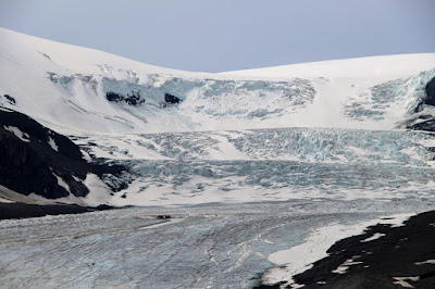
Athabasca Glacier flows in a flatter profile, spreading wide and averaging 500 feet thick. About 130 years ago, the toe (front edge) of the glacier was at the road. It is currently about 3.5 miles long. Its comparatively easy access makes it the most frequently visited glacier in the world.


The toe of the glacier used to be here in 1982. Notice the people in the background. They still haven't made it to the glacier's edge.


Walking the loop trail from the parking lot to the edge of the glacier. Access to the glacier surface is only through guided walks with boots, crampons, and parkas (provided), or ice coach tours that take you to a groomed spot in the center of the glacier. The ice is riddled with crevasses elsewhere, and signs behind these ropes tell tales of inattentive people falling in and dying of hypothermia before they could be extracted. All the gritty, dirty stuff at the front and sloping up to the right is also ice, not soil. We expected extremely cold air this close in, but we were in such a hot spell that even the breezes were warm enough to allow for wandering in shirtsleeves and shorts without freezing our nunzies off. 


An ice cave formed by collapsing ice in the face of that gritty black surface in the previous photo. All that glacially-moved surface gravel is hiding ice that is spectacularly blue.


The full surface of the glacier is more readily visible from afar than it is up close; this is taken from the visitor center. Double-click to see a couple of the touring ice coaches at the middle-left. By noon, we counted seven buses up there at once. The chance to walk on a glacier takes three hours (it's farther away than it looks and includes a stop at another non-glacier touring site), and we didn't have the time that day to do it. We were quite content to be able to picnic in full view of this magnificent icefield, however.


Closer to Banff again, this is another exceptionally famous (and often photographed) view of the Rockies: the Ten Peaks at Moraine Lake, a skyline that used to grace the Canadian twenty-dollar bill. Stunning from any angle.


Ah, yes, the bighorn sheep feeding station at Johnson Lake, near Banff. Not a feeding station per se, but an area frequented by them so often that they have become habituated to the parking lot and seem to prefer scrabbling for weeds rather than dining on the lush grass just across the street. Cars and people barely fazed them.


A gorgeous sunrise one morning had me bounding out of bed, donning arctic-ready clothing, and scampering outside in hopes of catching a light display. Not to disappoint, the bowl of Cascade Mountain went aflame with color, as if holding burning coals.


To the east, another mountain (Mount Girouard?) looked like it was spewing lava. 


And everywhere I looked grew the wild rose of Alberta, the province's official flower, happily blooming amid green forests and gray stone.